Map to the Mountains: New Haven to New Hampshire
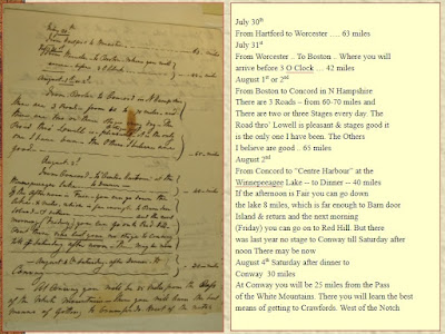
In 1827, Daniel Wadsworth sent a map and suggested itinerary for a trip to the White Mountains to Thomas Cole that was scheduled to begin 197 years ago today.
Today, that letter is in the Thomas Cole papers at the New York State Library in Albany (Box 3, Folder 7). See the link here.
The letter is written on one piece of paper and folded as was the custom of the time to serve as its own envelope.
Wadsworth sketched a rough map on the back of the letter (click on the images to enlarge them).
The map is outlined in the yellow box below.
Here is a detail of the letter and map with a transcription (click on images to enlarge them).
In a recent blog here we followed in the footsteps of Thomas Cole's final trip to the White Mountains in 1839. Thomas Cole is a world famous artist and considered the founder of the Hudson River School of Art. In this blog we will learn more about how he first got to New Hampshire and a little about his first trip here.
Details of Cole's first trip to New Hampshire are sketchy and Wadsworth's letter is one of the best pieces of evidence we have for the trip.
Let's start with Daniel Wadsworth, the man behind the letter, map and many of Cole's canvases.
Thomas Sully, Daniel Wadsworth, 1807
Wadsworth Athenaeum 1976.79
The Curatorial narrative from the Wadsworth Athenaeum website about this painting points out "The sitter dons buff leather gloves with red stitching, characteristic of those worn when traveling. Wadsworth was a romantic traveler and amateur artist in his own right, who searched for beautiful scenes to sketch. The dreamy gaze, tousled curly hair, and nonchalant pose add to the painting’s romantic sensibility." Wadsworth founded his museum in 1844. He was born in 1771 and died in 1848.
Wadsworth had the eye of an artist, but lacked the skill and talent to realize his vision. Fortunately for us, he had the motive and means to travel and the will to direct Thomas Cole to make the art he wanted for him.
His lack of artistic ability can be seen in an example from his sketchbook.
Source: Wadsworth sketchbook at Wadsworth Athenaeum p. 87
Some of the detailed visual information in the sketch also shows up in a print attributed to Wadsworth that was published (facing title page) in 1826 in the 2nd edition (with 1827 additions) of Theodore Dwight's The Northern Traveler.
To read the associated text (pp 311-314) online follow this link and start here.
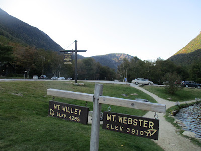
The view is looking north with Mt. Willey on the left west, Mt. Webster on the right east and Mt. Willard in the center north.
You can match the historic print to a more modern view through google maps in my entry in the theclio app here.
and my photo from the site with signs

Now you have your own map so you can follow in the footsteps of Daniel Wadsworth and Thomas Cole.


Comments
Post a Comment