Conway Village Triangle Park
insert pic flowers
June flowers
the left gate post has been hit and damages


x


a pre-printed blue lined
hand written, cursive black ink
On the cover, adhesive label outlined in red reads "Village Park Association."
The original can be found on our online catalog here. with it's Dewey Decimal number, call number that identifies it's location.
we have scanned it and it can be read here. The bound handwritten minutes book/booklet here at archive.org
There was also an incomplete but useful typescript/transcript of much of the original record book (5 pages) here. here. (note this searchable by keyword)
can the untranscribed pages be seen in the scanned bound book above?
and the envelope and "loose" papers here.
and found at the cpl hhr collection here.
The papers tell the origin and early history of the Conway Village Park, or triangle park
The park not far from the Conway Public Library,
x

In previous blogs We have focused on the mill area here and on the "four corners" intersection of Conway Corner here. (highlight with different color boxes, insert that below?
Our attention now turns a bit north to the upside down triangle seen up by the river in the 1860 map below. to a series of maps that when read properly tell insights into the story changes over time. insert detail this map (click on images to enlarge them).

x


x
the canal used to provide power to a turbine for a chair factory
dam, mill pond system
insert sanborn map/s
seen on 1908 Sanborn Insurance map for Conway online here.
x


You can see "lumber shed" top left. The wooden building and it's 50 foot brick red chimney.
The main building (detail of that) inner workings, even the location of the office, turbine and dynamo. It notes that the turning and bending operations were on the first floor and the assembly was on the second floor.
shows a connector on the second floor above the open platform between the two parts of the building, is then in the photo/s?
x

x
insert comparative photos of the chair factory and chs chair made there
This area was an important, probably noisy, smoky, smelly part of the town and today is an interesting area to explore. try to reveal, unpack some of those landscape features
how it is much more calm, placid today
at some point tie/link to theclio com on this/these areas
previous blogs explored manufacturing center on Main Street and ice harvesting set up on Pequawket Pond here and here.
in 1860 map showed a tannery, then 1892 showed...
now 1908 showing Conway Chair Co., then Barnstormers Theater, Veterans Post, now Tee shirt co.,
one of a number, tannery turn hides into leather, more on this
leather for shoes, belts, blacksmith aprons, harness, razor straps, hundreds of other products, local shoes, how many of you have shoes made in Conway? two hundred years ago, most of your shoes would have been made here.
little/few physical traces of that industrial history so turn to other maps and photography, and items in museum
insert here about maps, or later after the paper trail leads us there
by 1892 atlas

x
bbbb

kkk
detail

1896 birds eye view
x


sanborns
modern google maps and street view
The record book (minutes of the Village Park Association) start January 30th, 1891 with ten people forming themselves into a "copartnership."
They meet at the Conway Savings Bank


x
insert photo detail of the sign over the bank door
as it looks today, Saco River Medical Group (redo photo so it is from the same direction)

series of remarkable maps 1860, 1892, 1923
triangles common due to space needed to turn horse drawn wagons around

The 1923 Conway Sanborn map above
start with photo of the coffin shop
follow up recent question on facebook about Conway Village Park,
replied on facebook, but also wanted to post it as a blog

1929 Conway Sanborn map above
ghi


x
ghi
article 1 and 2 explains that each of the ten copartners were to pay thirty dollars for a total of three hundred dollars and that to be paid to J.B. Smith "for his triangular lot bounded by the highways from Conway Village to the Saco River bridge and Swift River bridge respectively and the lot on which the said Smith is now building his new ladder shop..."
so now we have evidence, clue/s, suggests that the new ladder shop was new, being built in 1891
the 1892 Hurd Atlas says this about Smith
and the 1896 birds eye view says this about Smith.
Hounsell says this in her book Conway, New Hampshire.
Smith was "to reserve a driveway only between his new building and the lot as above described."
a hint of what was there in the minutes, article 3
refers to a "red shop" and "hay scales"
can also see old photos of the area, showing the coffin factory, etc.
photo can be in the hhr collection here.
overall

and detail

x
sign on dark building on left reads "FRED EATON, Mfr OF CASKETS and COFFINS"
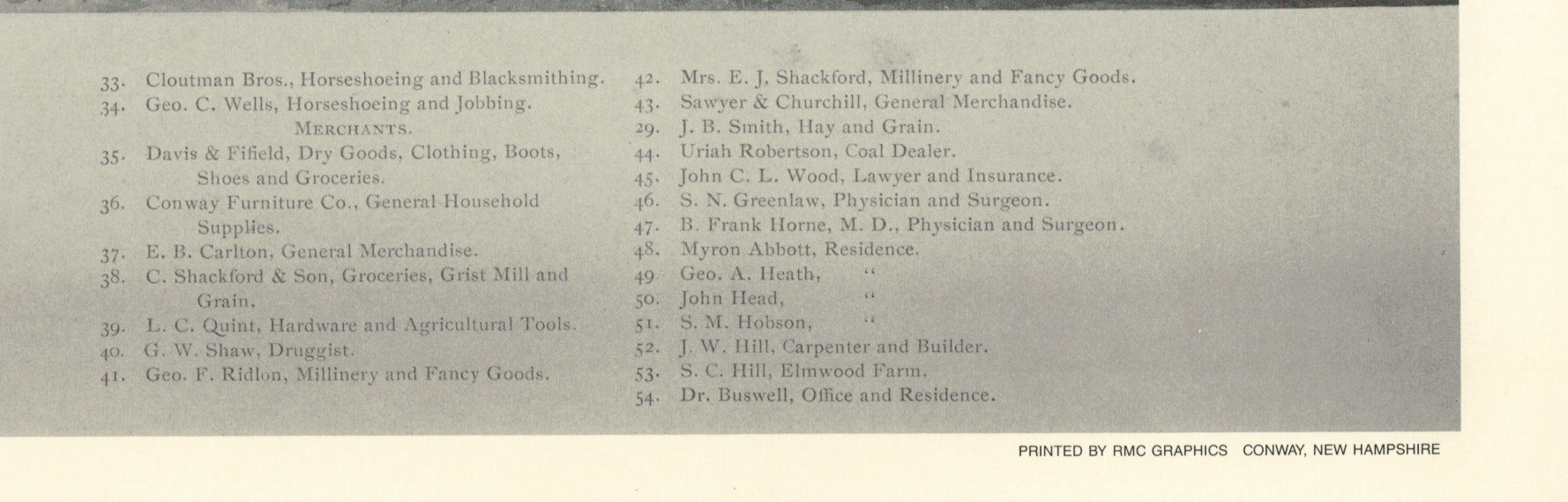
see 1892 Atlas, numbers 29
even at 600 dpi can not read the three signs on the right.
sign on granite post has three lines with the silouette of a hand with a finger pointing left
behind that road leads to the small building on the left and the bridge on the right
sign on building on the right reads
and 31
the copartners to assess themselves five dollars apiece for fencing, grading and grassing the lot and to plant shade trees to "transform the said lot to a pleasant Park"
next to that text is a sketch of the triangle shape of the lot
There are no records for six years, then on January 2nd, 1897 records Mr. H.B. Fifield assigns his interest ... to Frank W. Davis.
1900 repair the fence
some transactions
until 1926 when the "remaining owners of the Village Park" donated it to the Town of Conway.
Now to the scrap paper/s.
insert pic/s of the original cover, handwritten pages, and the typescript? where are those jpegs, the pic of the triangle is kind of neat
and the typescript ocr scanned with links and pics inserted of the ladder company, etc.
ongoing cataloging
google maps, of the park here.
satellite view here.
you can take a spin around the park with street view here. (but only along West Side Road. The other two sides of the triangle not in street view?
previous blogs looked at photos in our collection, sanborn maps, etc.
From here you can also have it read the text out loud to you.
(and/or shared via mwvhistory google photo album/s) or both
also were these "papers" of the Village Park Association
tie this to theclio com as the place, triangle park
xy
x
add Sanborn map/s, 1892 and 1860 maps tie those to the names of folks listed here
papers in envelope conway bank, map that, insert photos that bank, now site of x
scrap paper, the papers mostly? receipts, handy piece of paper, not intended for posterity, but revealing, enlightening, a real treasure as so much local history has been lost. closer, intimate to history, that was not preserved, see Hounsell on this park and on these folks also Merrill, History Carroll County
z


Comments
Post a Comment