Hard Map to Read
abc
other titles
other titles
hard maps (plural) to read
rock maps
maps that rock (and a tusk)
follow up from previous blog on read a road map day here
upcoming relief map program chs ofh on x date here.
now let's go way back in time, from the future,

x
 x
x
 x
x
 x
x
 x
x
 x
x


x
.jpg) x
x
Abauntz Lamizulo Rock Map
Year Created: c.14,000 BCE
Country of Origin: Navarre, Spain
Creator: Unknown – possibly Magdalenian hunter-gatherers
Materials Used: Engraved rock
Area Depicted: Area around Abauntz Lamizulo cave and animals such as red deer and ibex
x
x
The map engraved into a hand-sized rock found in the Abauntz Lamizulo cave in the Navarre region of Spain is believed to be the oldest map ever found in Western Europe. The rock was initially discovered in 1994 but it took researchers about 15 years (2009) to decipher the meaning of the etched lines. According to the research team led by Pilar Utrilla from the University of Zaragoza in Spain, “All of these engravings could be a sketch or a simple map of the area around the cave. It could represent the plan for a coming hunt or perhaps a narrative story of one that had already happened.”
The research team believes that the cave would have been a strategic location for the hunters who probably drew out the map. Further evidence backing up the belief that the map depicts the area around Abauntz Lamizulo is the drawing of the mountain, San Gregorio, that can be seen from the cave.
x
 x
x
x
Lascaux Cave Star Map
Year Created: c.17,000 BCE
Country of Origin: near Montignac, France
Creator: Unknown
Area Depicted: Area around Abauntz Lamizulo cave and animals such as red deer and ibex
x
x
The prehistoric paintings found in Lascaux caves are some of the most beautiful and well-known pieces of art left by our ancestors. There are thousands of figures of animals, humans, and abstract signs in the paintings and many interpretations of what the paintings represent have been presented over the years. One of the more recent theories suggests that some of the paintings may have been prehistoric star maps.
According to German researcher Dr. Michael Rappenglueck of the University of Munich, some of dots in the area of the paintings known as the Shaft of the Dead Man correspond with constellations such as Taurus, the Pleiades, and the Summer Triangle. Another researcher, Chantal Jègues-Wolkiewiez, believes that the Great Hall depicts an extensive star map with key points on major figures corresponding to stars in the main constellations from the Paleolithic.
x

x
Mammoth Tusk Map
Year Created: c.25,000 BCE
Country of Origin: Pavlov, Czech Republic
Creator: Unknown
Materials Used: Engraved mammoth tusk
Area Depicted: Mountains, rivers, valleys, and routes around ancient Pavlov
x
x
The mammoth tusk map from the village of Pavlov in the Czech Republic is believed to be the oldest known map in the world. While archaeologists aren’t completely sure, the markings on the tusk may have depicted the landscape of Pavlov at the time. Researchers also think that the mammoth tusk was used as a hunting map.
The curved markings are thought to represent the Dyje (Thaya) river. There are also symbols that show clay slopes that disappeared in the 20th century after being used to make a brick kiln. The map also shows the foothills where the river met the clay slopes and is represented by a double circle. The original mammoth tusk map is stored in the Archaeological Institute of the Academy of Sciences of the Czech Republic in Brno.
x
dlj
z
now let's go way back in time, from the future,
Did You Know…
…that the Turin Papyrus is thought to be the oldest recorded road map in the world? Historians believe that it was created around 1160 BC.
History Of Read A Road Map Day
history of ...
…that the Turin Papyrus is thought to be the oldest recorded road map in the world? Historians believe that it was created around 1160 BC.
History Of Read A Road Map Day
history of ...
the earliest road map in the world, believed by historians, was the Turin Papyrus which may have been created around 1160 B.C. The earliest known recorded road map was the Britania Atlas. In 1675, cartographer John Ogilby drew the first road map, which was recorded in that atlas.
Turin papyrus
x
.jpg)
 x
x
Turin papyrus
x
x
needs to be decoded, revealed
click on images to enlarge them.
x
.jpg)
source: here.
x
adding text labels and arrows helps interpret this otherwise arcane obscured meaning.
other graphic, pictorial ways to help explain, unpack, decode,
sketch
x

x

x

x

x

x

x

x

x
source: here.
x
text here
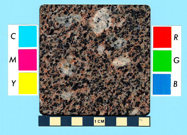
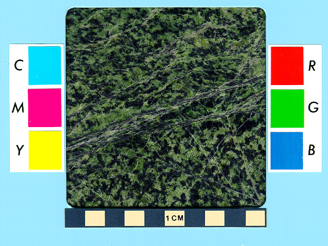
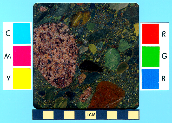
The map shows the landscape along a wadi, the Arabic name for a dry valley in the desert. The profile of the mountains is projected onto both sides of the valley. Inscriptions describe the "Mountain of the Gold”, the “Mountain of the Silver”, but also the location of the “Village of the Miners”, the "Mountain or Temple of Amun", the streets to the (Red?-)Sea and a street to the (today lost) city of Ta-menti. The different colors shown on the map are inspired by the real colors of the rocks, reddish-pink feldspar-granite (Fawakhir-Granite), dark Atalla-Serpentinite and blue-green Hammamat-Sandstone, and yellow for the sand of the desert. The river follows the entire valley, eroding and transporting the rocks, as shown by the pebbles with different colors in the riverbed. A quarry of bekhen stone, the sandstone used to carve the statues, is shown, as are many veins of gold. The most important indication was the location of a well near the village. Thanks to this well, the archaeologists identified the area shown on the map. The ancient mountains of gold and silver are situated along the Wadi Hammamat, near Bir-Um-Fawakhir, an ancient miner settlement, almost 62 miles east of Luxor. Following the indications of the map into the field, the archaeologists discovered ancient signs of mining, like 160 feet deep tunnels following massive quartz veins. The most important veins are also shown as undulating lines in the Turin-map. The gold is only rarely found als large crystals of native metal, it is quite more common to find the gold as tiny fragments distributed randomly in the massive quartz-rock, almost invisible to the naked eye.
The Turin-map, of course, is more of a treasure map or topographic map with indications for miners, as it is a true geological map. The rocks are not identified or described in detail, and the map contains no stratigraphic information at all. Nevertheless, it´s a unique document, a beautiful and rare testimony of the keen practical and geological observations of the ancient Egyptians.
x
from here.
x
The Turin Papyrus Map is widely considered the oldest existing topographical map from the ancient world. The map was created around 1160 BCE and due to diligent ancient Egyptian record keeping, researchers know who drew the map and what it was for. The map was drawn by a well-known scribe Amennakhte and prepared for Ramesses IV, who wanted to quarry the Wadi Hammamat in the Eastern Desert. Ramessess IV wanted to use bekhen-stone (metagraywacke sandstone) to build statues of himself.
Depicted in the map is a 15-kilometre stretch of Wadi Hammamat and shows where the wadi merged with wadis Atalla and el-Sid. The map also shows the surrounding hills, the bekhen-stone quarry, and the gold mine and settlement at Bir Umm Fawakhir. In addition to being the oldest topographical map, the Turin Papyrus Map is also the earliest known geological map because it showed the local distribution of different rock types, the diverse wadi gravels, and contained information on quarrying and mining.
x
x
the following from here.
x
x
Turin Papyrus Map, c.1150 BC
Kate Wiles surveys one of the world's oldest surviving maps, prepared for a quarrying expedition led by Ramesses IV.
Kate Wiles | Published in History Today Volume 66 Issue 8 August 2016
It shows a 15km-stretch of the Wadi Hammamat, the ‘Valley of Many Baths’, oriented with south and the source of the Nile at the top. Shown on this portion of the map are a quarry for bekhen stone, a prized blue-green material used to carve statues of gods and pharaohs, and a gold mine. Nestled at the foot of some hills (stylised cones with pink, wavy flanks) to the north are four small houses for gold-workers, which are close to a temple to the god Amun. The map also shows the locations of various rock types, including gold-bearing quartz, which is represented by three pinkish stripes on the hill at the top, above the gold mine. Inscriptions elsewhere describe the purpose and destination of the quarried stone.
x
the following from here.
best detailed toledo article
x
x
focus of turin map is rocks, geology
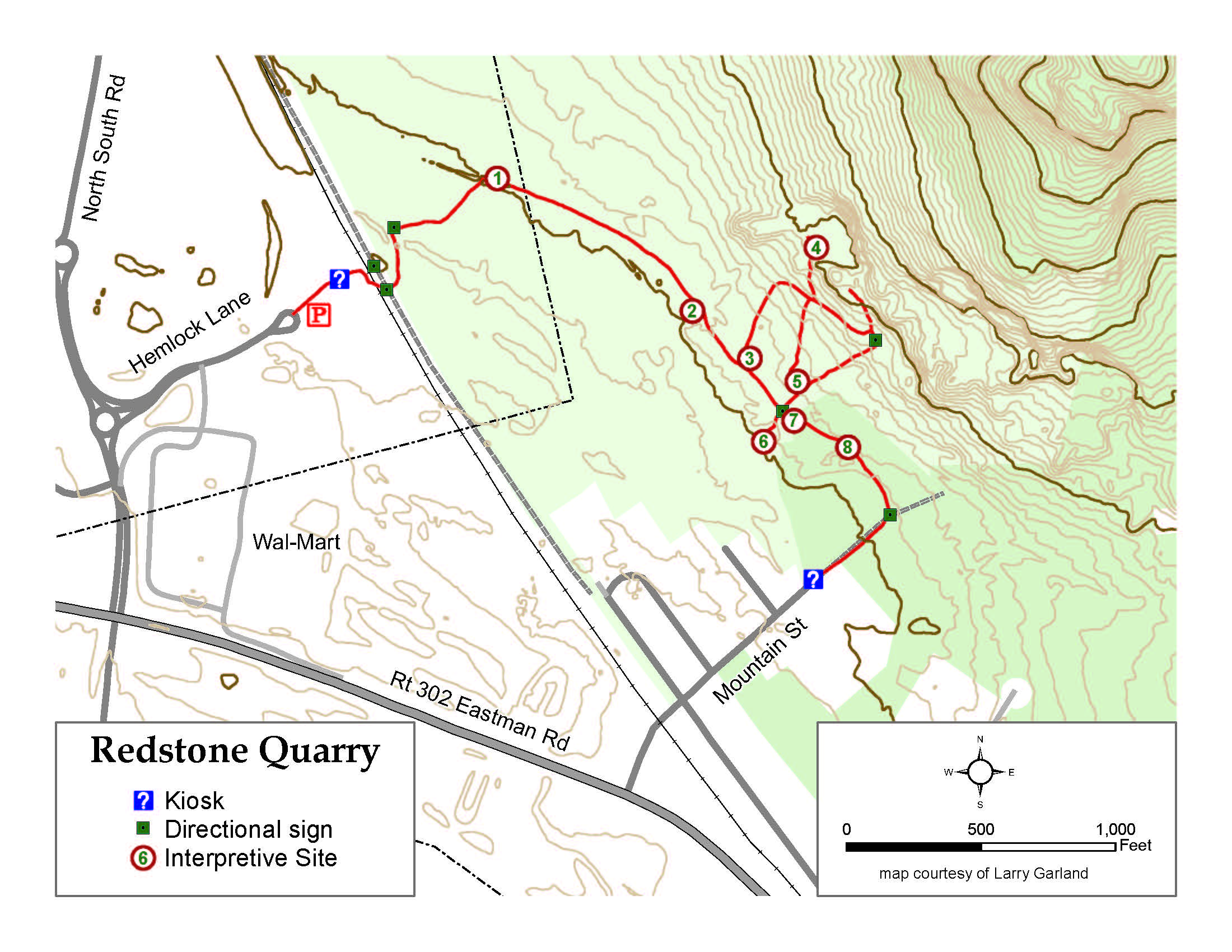
tie to larry garland redstone trail map
click on images to enlarge them
x
x
link to draft field guide? or FMI contact us
x
FMI Turin papyrus here.
other ways to interpret, explain, illustrate the turin map
sketch
x
x
source here.
an even older rock map here
x
.jpg)
Abauntz Lamizulo Rock Map
Year Created: c.14,000 BCE
Country of Origin: Navarre, Spain
Creator: Unknown – possibly Magdalenian hunter-gatherers
Materials Used: Engraved rock
Area Depicted: Area around Abauntz Lamizulo cave and animals such as red deer and ibex
x
x
The map engraved into a hand-sized rock found in the Abauntz Lamizulo cave in the Navarre region of Spain is believed to be the oldest map ever found in Western Europe. The rock was initially discovered in 1994 but it took researchers about 15 years (2009) to decipher the meaning of the etched lines. According to the research team led by Pilar Utrilla from the University of Zaragoza in Spain, “All of these engravings could be a sketch or a simple map of the area around the cave. It could represent the plan for a coming hunt or perhaps a narrative story of one that had already happened.”
The research team believes that the cave would have been a strategic location for the hunters who probably drew out the map. Further evidence backing up the belief that the map depicts the area around Abauntz Lamizulo is the drawing of the mountain, San Gregorio, that can be seen from the cave.
x
z

x
Lascaux Cave Star Map
Year Created: c.17,000 BCE
Country of Origin: near Montignac, France
Creator: Unknown
Area Depicted: Area around Abauntz Lamizulo cave and animals such as red deer and ibex
x
x
The prehistoric paintings found in Lascaux caves are some of the most beautiful and well-known pieces of art left by our ancestors. There are thousands of figures of animals, humans, and abstract signs in the paintings and many interpretations of what the paintings represent have been presented over the years. One of the more recent theories suggests that some of the paintings may have been prehistoric star maps.
According to German researcher Dr. Michael Rappenglueck of the University of Munich, some of dots in the area of the paintings known as the Shaft of the Dead Man correspond with constellations such as Taurus, the Pleiades, and the Summer Triangle. Another researcher, Chantal Jègues-Wolkiewiez, believes that the Great Hall depicts an extensive star map with key points on major figures corresponding to stars in the main constellations from the Paleolithic.
x

x
Mammoth Tusk Map
Year Created: c.25,000 BCE
Country of Origin: Pavlov, Czech Republic
Creator: Unknown
Materials Used: Engraved mammoth tusk
Area Depicted: Mountains, rivers, valleys, and routes around ancient Pavlov
x
x
The mammoth tusk map from the village of Pavlov in the Czech Republic is believed to be the oldest known map in the world. While archaeologists aren’t completely sure, the markings on the tusk may have depicted the landscape of Pavlov at the time. Researchers also think that the mammoth tusk was used as a hunting map.
The curved markings are thought to represent the Dyje (Thaya) river. There are also symbols that show clay slopes that disappeared in the 20th century after being used to make a brick kiln. The map also shows the foothills where the river met the clay slopes and is represented by a double circle. The original mammoth tusk map is stored in the Archaeological Institute of the Academy of Sciences of the Czech Republic in Brno.
x
now to less distant maps space and time
HHR Bond 1853
from this book, we have two copies here.
map from this book here. (need to add images to these entries)
map here.
HHR Boardman 1858 map here.
while the idea of this holiday is to go "old school" and read a paper map, you can read a road map on your cell phone or computer, tablet, device.
a favorite of mine, beyond google maps is theclio here.
it's focus is on historic sites
turn on your location and it reveals historic sites that have been entered
we have added a number of entries in the Mount Washington Valley area and have a long list of sites to add, actively adding.
with links to archives and artifacts and blogs tied to the site.
the cpl hhr also offers free outreach programs to schools on maps and map making. how to read a map
insert pics from previous outreach, survey compass, globe, etc.
dlj
z


Comments
Post a Comment