White Horse Ledge

send draft to Athea
others for permission
before posting
then do a theclio on this easel spot for this painting and for intervale scenic vista too
fascinating "field" of study
field of view
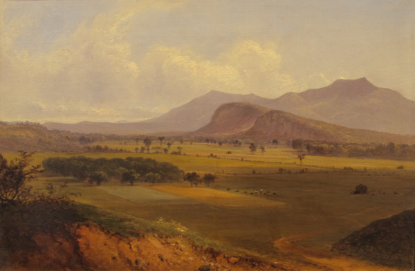
At first glance, the painting above seems like a pretty generic landscape that could be almost anywhere in the foothills of the Appalachian Mountains from Maine to Georgia.
It is in fact, a view from North Conway, New Hampshire, now in the collection of the High Museum of Art in Atlanta, Georgia. For more information on it there see this link here. (I am indebted to Athea King, Assistant to the Chief Curator and Director of Collections and Exhibitions at the High Museum of Art for her assistance with research on this painting).
It is a relatively small (15 x 26 inches), oil on canvas, that depicts a vast view across a broad field towards a sun setting behind a shadow bound defined mountain range and back lighting the clouds in a variety of white, silver, gray and pink. From an aesthetic perspective it would be considered an average painting, nice but unremarkable.
As we shall see in a moment, it is an "unfinished study." However, for a small, unfinished painting of average quality, it is actually an amazing historical document with meticulous details painted by an artist with keen observational skills and an intimate familiarity with the site.
If you look closely, it records a number of unique and distinctive features that when "reframed" in context with period maps, guidebooks, modern photos, newspaper articles, and other art works help reveal a narrative of changing attitudes towards a specific landscape over time from a variety of different perspectives.
So we will go beyond curatorial aesthetics, the paint surface, through the looking glass, and use this painting as a valuable tool, before color photography was available, to read, reveal a lost landscape. This painting can serve as a window into the past. virtual visit, through space and time.
on its surface, landscape art about depicting, a place in time, at a specific time, use the painting in combination with other disciplines, to understand, explore that space. different dimensions, different stories, different narratives, especially interesting if surprising, unexpected
While much of the "field of view" has changed, remnants of the scene can still be seen today,
tomography, slices, sections as in science, cat scan
to write, to describe
tomograph
tomogram
focal plane
some obscured, some partial, some changed, , painting as a tool to uncover meaning behind the palimpsest we can view today, lost buildings, connections, etc. reframe, context
taken within context, and looked at from different perspectives, it takes on added levels of significance.
into the realms of the tourist, geologist, glaciologist, rock climbers, hikers, cross-country skiing, snowshoeing, ice climbing, kayaking,
loggers and quarrymen who saw a different kind of product, more destructive use
then activated preservationists
For a number of years, I have been using art to inform history, nature and science and using multiple perspectives academic disciplines, recreational and extreme sports to inform art.
in different projects I have worked with specialists to provide unique perspectives on art including an anthropologist, architect, botanist, conservation commission members, farmer, ranchers, meteorologist, maritime historian, politician, cartographer, theologian, poet, etc. (see notes vitae re: florida painters and old miakka grant)
loggers and quarrymen who saw a different kind of product, more destructive use
then activated preservationists
I like to expand an artwork's interpretation to space and time and multiple disciplines, perspectives, botany, zoology, agricultural history, architecture, material culture, science, conservationist, etc.
For another example of my multidisciplinary approach to art, you can check out a video from the "Luminous Terrain" exhibit here.
add list approaches i took, cow colors, farm tools, etc.
The High Museum's website lists the painting title as Moat Mountain and White Horse Ledge, Study, North Conway, New Hampshire and the artist as James David Smillie (1833-1909). It is dated September 1867.
It is not clear from the available records how this painting came to have "Moat Mountain and White Horse Ledge" in the title, but the description is accurate.
Can you spot the "white horse" for which the ledge is named? It is right there near the center of the painting. White horse ledge was a popular tourist destination in the nineteenth century and remains so today, but for different reasons that would shock those early tourists. (I'll give you a hint: it has to do with carabiners, cracks, shallow dihedrals and spectacular dikes).
Can you see Echo Lake? This spot, once hosted a small cannon for tourists who were thrilled to hear a series of echoes bouncing off the nearby ledges. It can be seen in the painting too and again its function has changed over time. There are no more cannons, stage coach horns or rowboat rentals there anymore.
You can also see the forests once coveted by loggers, stone slabs that were quarried and carried off, and other natural features that when threatened rallied the community to preserve the land you see in the painting.
The painting depicts fertile fields that are still farmed today yielding products that are sold at a local farmer's market a short distance from the "easel spot" where this scene was painted.
Let's start our odyssey into art by looking closely at the bottom left corner of the painting using the zoom feature on the High Museum website. You can read the inscription in red lettering Unfinished Study. and below that North Conway. Sept ’67. (click on images to enlarge them).

While paintings are often signed, titled and dated it is unusual to have the phrase "unfinished study" written on the front.
I have always been fascinated by the loose atmospheric character of oil studies. Like pencil or charcoal sketches, these initial impressions can provide insight into the creative process. With their loose brush strokes, rough mixing of colors, scumbling, and other subtleties they can seem in many ways more alive and vibrant than highly finished works. I even appreciate the patches of bare canvas.
I also love to compare these oil, water or pencil sketches with the finished artwork. The website White Mountain Art has a exploratory technique feature for doing this. pioneered by our/my friends there. See this link here.
Warren Schomaker, Curator at the Jackson NH Historical Society, has mounted a number of ground-breaking exhibits that have compared iconic White Mountain scenes from sketch to canvas. He has included photo comparisons as well as poetry, literary references, whiskey bottles, and historical artifacts in his exhibits to help explore the art.
They also have a large relief map in the center of the gallery.

It is my contention that you can not have a serious landscape art exhibit without a map, especially one like this that allows you to orient the paintings to the topography in the map.
Let's return to the painting and follow the road on the left as it leads our eyes into the scene. letting the painting reveal itself to us.

The road curves up and down and past a copse or group of trees which I suggest is an apple orchard. (click on image above to enlarge it and study the trees).
Describing a tourist trip to White Horse Ledge, Sweetser's 1890 guidebook to Southwestern New Hampshire mentions an orchard of gnarled apple trees (p. 14, see it here).
Let's now continue our journey past the apple orchard through the painting and into the wide, broad intervale of the Saco River.

The river itself is actually hidden out of sight, but notice the little bit of blue towards the right at the edge of the forest on the other side of the open field in the image above. That is Echo Lake. We will come back to that later.
From the farmer's perspective the open fields between the orchard and the ledges were the most valuable type of land. Known regionally as "intervale" land.
evidence of extensive farming. look closely see fence and field patterns.
FMI on field patterns see Frosty woods blog here.
x
The intervale land is the result of regular flooding of the Saco River which also creates a pair of terraces on both sides of the flood plain.
x

Sweetser's 1890 guidebook to Southwestern New Hampshire reports that "North Conway occupies a situation of peculiar beauty, on a shelf-like terrace in the great eastern portal of the White Mountains, where the Saco River flows down through broad intervales, over whose beautiful emerald floor the vase central range is seen with the best possible effect." (p. 11, see it for yourself here).
I enjoy the flamboyant florid language of nineteenth-century guidebooks. I think that this is a pretty good literary description of this painting.
word pictures in words, pictures also preserved in words of period guide books.
also in period guide books
particular language on the nineteenth century (later we will see how described by different outdoor enthusiasts in different language) landscape language, language of the landscape
has changed over the years
such as 1876 Sweetser here. pp. 71-86
or see our original copy at the Conway Public Library's Henney History Room.
see in ryan's room, esp for the profile pics, like map, to scan?
seems like these maps already pulled out and in flat files at hhr room,
check that
His 1876 edition,
period guide books
such as 1876 Sweetser here.
provides interesting context
p. 73
"The most beautiful features of the scenery .. are the broad intervales..." Arcadian air.. sweet pastoral beauty."
houses swept off in the flood of 1800.
In the painting, you can see the terrace on the opposite (west side) of the open field known locally as "intervale" there at the base of the ledges.
The "easel spot" for the painter was on the edge of the terrace on the eastern side of the intervale which is why the painting has an almost "bird's eye" view above the intervale. (more on this later).
In 1792, historian Jeremy Belknap used clear, simple descriptions in fascinating period language and script, (using f in place of s). using the medial S, also known as the long S, to explain about the role of the Intervale flood plain.
esp interesting p. 128. read it online here. or see our original copy at the Conway Public Library's Henney History Room.
x

It reads ... "There is a great variety of soil in New-Hampshire. The intervale lands on the large rivers, are accounted the most valuable, because they are overflown and recruited every year by the water from the uplands, which brings down a fat slime or sediment, of the consistence of soap. These lands produce every kind of grain in the utmost perfection; but are not so good for pasture as the uplands of a proper quality."
p. 66-69
ox-bows horse shoe ponds
"... rivers change their courses, and leave their ancient channels dry... In some places, these ancient channels are converted into ponds, which, from their curved form, are called horse-shoe ponds..."
"The banks of the upper and lower intervales, are often parallel to each other, and when viewed from the opposite side, appear like the terraces of an artificial garden.
67-68 freshets every year
"Every Spring there is more or less of a feshet, caused by the dissolving of snow in the woods and mountains...
68-69
Floods also occurred in the Autumn. Belknap describes floods in October 1775 and October 1785.
"Stacks of hay were carried off, cattle were drowned or otherwise killed, and the Indian corn, then ripe for harvest, was destroyed."
"Saco river has risen twenty-five feet, in a great freshet; its common rise is ten feet."
Belnap's book served as a how to manual, guide for settlers interested in farming the area.
after the slime, next few pages he explains how trees serve as indicators of the soils and agricultural uses
insert some of that here
"...the soil is distinguished by the various kinds of woods which grow upon it, thus: White oak land is hard and stone, the under growth consisting of brakes and fern; this kind of soil will not bear grass, till it has been ploughed and hoed, ..."
he goes on to describe other types of soils, trees, and how to prepare for the land for specific crops.
These fields were a popular subject for artists as well as farmers.
symbiotic relationship
farmers hayed the fields, keeping open for artists and tourists they attracted
in many places the trees have grown back in blocking the view we once had
preserved now only in the paintings.
Were it not for ongoing farming (and two golf courses) we would probably not be able to see this scene today.
The continuity of farm and recreation in this painting can also be seen in the logo of the friends of the ledges who help preserve the landscape seen in the painting.
x

friends of the ledges logo here. include farming furrows that emphasize the continuity of agricultural history, farming furrows.
local food movement here. (keep or cut this bit about the farming?) here or down below when do the intervale? and the ridge?
or say farmed with new tools and techniques
x
unique valley originals here.
x

x
This recent resurgence thriving local food is a reflection of a period when hotels promoted local foods, often had their own gardens, dairy cattle herd, was Kearsarge Hotel, ads, menus, pr for health, sanitary reasons
today along the Saco intervale are upick apples, strawberries, whiskey distilled, maple sugar, syrup, native corn, beer brewed, beef raised,
sold at farmer's market stone's throw from the "easel spot" for this painting.
you can see more historic intervale farming from another popular easel spot a few miles north.
looking from the scenic vista we will examine the intervale view from the perspective of the farmer, then geologist, then recreational tourist, local kayak, x country ski, snowshoe, etc.
farmer views field as fertile, place to raise crops and livestock
note many of the paintings from this angle show haying activities.
previous blogs
looking at is glacial till
fitz
x
x
In this painting by Benjamin Champney. you can see a similar apple orchard, and similar field and fence patterns can be seen
you can also see haying activities in many of the artworks from this viewpoint (easily accessible from the intervale scenic vista here link to theclio
fmi on this painting see wma com here.
x
x
looking from the scenic vista we will examine the intervale view from the perspective of the farmer, then geologist, then recreational tourist, local kayak, x country ski, snowshoe, etc.
farmer views field as fertile, place to raise crops and livestock
note many of the paintings from this angle show haying activities.
previous blogs
looking at is glacial till
There are in fact three similar paintings of that same view by Champney. Note the shadows and placement of trees don't match.

A third similar painting by Champney showing the fields was sold at The Cobbs in 2017. the apple orchard can be seen in the lower left in the foreground.
x

x
FMI on that painting see here.
and on wma here.
More paintings of the North Conway Ledges can be found wma com here.
x
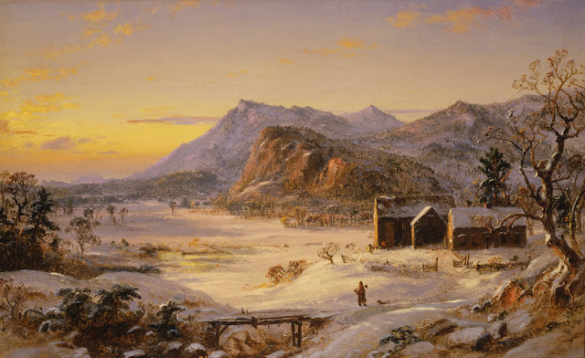
White Mountain winter scenes are relatively rare during the nineteenth century.
here is painting of the ledges from near the intervale scenic vista
insert Cropsey currier winter view ledges and the intervale
x
x
x
FMI see currier here.
why this not on wma com?
For other winter wma see wma com here.
winter scenes depicts documents both work and fun
x
While snow shoeing part of 19th century experience, only in past 25 years? see history section website, cross country skiing now ... (this actually north of the scenic vista)
Mt. Washington Valley Ski Touring and Snowshoe Foundation,
groomed trails
FMI here.
also sleigh rides offered Farm by the River here. (closed temp during covid).
One of my favorite paintings by Albert Bierstadt show the intervale fields from a slightly different angle.
x

FMI see their website here.
previous blog here.
and bierstadt here. ? did I not blog this?
previous blog here.
refer to my chapter in book? or hit some of the highlights here? list approaches I took
soil science, botany, folklore, folklife, etc. family history,
orchard here? maybe on the left?
glacial till
do the glacial till geology first, before plucking? or after or where?
need to add pics that bit from www here.
fmi on this view see my article "Patterns in the Landscape" in Beyond the Notches, pp. 103-108, where I cover the role played by settlement history trends, folklore, fire, soils, plants, ecology, history, geology, agricultural history, floods, hydrology, in shaping this view. see scan and post link to archive org and/or expand on it with my old notes
Bierstadt is known to have used photography as a way to record a scene to help with his painting. Compare the painting above with the photo below.

For more on this photo see this link here.
If you want to visit the easel spot for yourself, visit at the Intervale Scenic Vista
for directions see google map here.
Compare the Bierstadt painting and photo above with the one below I took at the north end of the Intervale scenic vista parking lot closely matching the Bierstadt painting (click on images to enlarge them).

note top of White Horse Ledge touches the "valley" just below Red Ridge of the moat mountains. (the actual easel spot for the Bierstadt painting is a little further north on private property).
click on image to enlarge it and look at detail of the "match."
again note the terrace, bank, above the intervale.
x
notice the "bunker" as Mr. Cannell used to call it, was built into the bank, terrace that runs throughout the town. and plays an important role in the history of art here.
x
and theclio entry here. this goes to cathedral ledge the clio, need to do entry for the scenic vista
From the scenic vista you can see a panorama vista, that within a short distance, features three major views wma more on this in future blog/s.
appropriately several signs in front of the scenic vista building, acknowledge the role of the site in art history. and the local family that preserved and donated the viewpoint, view.

x
x

A roadside marker outside of the visitor center acknowledges the role of the area in the development of the so-called "White Mountain School of Art."
x

The Cannell family have operated a store across the street for many years that in addition to selling great food also serves as a museum of sorts. On display is a period buckboard like the one described in the tourist guidebooks. link to that here.
or just the reporter news bit? here.
x

x buckboard like described in guide book put here or elsewhere?
thrill of fording the Saco in a wagon like this.
online Reporter News from 1942 here.
"Often, fording the Saco River nearly opposite Lucy Farm - giving them quite a thrill as the water came over the floor of the ten-passenger buck-board and feet were drawn up to escape a wetting..."
x
Cannell store was site of group of hotels and center of tourism
motel in the news for height and tree
view from Intervale
do here or above?
Intervale also used for the census designated place
spreading on both sides conway and bartlett,
www here.
scenic vista was a popular easel spot wma
put this later?
or say in future blog, we will explore these other two viewsheds
and by comparing these paintings, able to create for of a 360 vr, virtual tour, explore the intervale fields
major works of wma
insert champney and bierstadts here of those two views
harmony sam robbins and mount washington
insert map from the echo, rambler map
insert map hotels intervale
and the book getting from the hotels in Intervale to the cathedral was an adventure in itself
there was a ferry, then a floating bridge then ferry? more on this from Aileen M. Carroll's The Latchstring Was Always Out available at the library. pp. 76-78, also Hounsell, Emerson, etc.
also across the street from the scenic vista were a group of hotels,
hotel, height, view and cutting tree an issue today


x

and a larger number of hotels on the ridge on the east
perhaps that photo x collection, forgotten nh, showing hotels
x
x
map of these hotels too, the wm echo news map, different part of same map?
tell story from reporter news getting feet wet crossing the ford,
bierstadt and inness, etc. painted this ford, or a nearby ford,
x delta
note white horse ledge and echo lake
many of these spots popular with artists.
below same list printed in hotel guide.
x
x
list of attractions from the Intervale House, one of a number of hotels in the area, see previous blog here.
another attraction abenaki indian shop
see the clio entry here.
collections preserved being cataloged chs and hhr
x
now we have explored the vista view from the farmer's and tourist's perspective, let's revisit the view bierstadt and others of the scene from intervale vista from the geologist's perspective
x shark
zebra
x
cut if used before
fmi on this view see my article "Patterns in the Landscape" in Beyond the Notches, pp. 103-108, where I cover the role played by settlement history trends, folklore, fire, soils, plants, ecology, history, geology, agricultural history, floods, hydrology, in shaping this view. see scan and post link to archive org and/or expand on it with my old notes
x
do here as good place, best place to see geology roche
From the scenic vista, you can see how the classic iconic "sheep back" shaped ledges known in French as "roche moutonnee" For more information see this link here.
x
fmi see previous blog here, (has glacial plucking pics, virtual bob, etc.), theclio here (need to do), wma com here.

The characteristic rock cliffs that we see are the results of glacial polishing and plucking and ongoing freeze and thaw cycles.
The characteristic rock formation that we see here ongoing freeze and thaw cycles.
insert rock fall, talus slope here or elsewhere? maybe with bierstadt currier
when do that be sure to compare currier photo bierstadt with painting
to better understand what is going on here geologically let's go back around 10,000 years ago when this area was covered by glaciers.

note the "farthest fallen block" it below.

now go up along the talus slope
define this term,
talus cone

fmi see this link here.
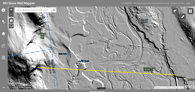
lidar here beta?
lasers from space illustrate some of these points, and show the "ancient" old courses of the rivers and the horse shoe bends, ponds and the terraces on either side of the Saco intervale.
see patterns, evidence the ever changing courses
insert lidar here? or say later we will look at some maps and photos showing the patterns made by the winding Saco River ....
compare view shed from intervale scenic vista and the country club view
canyon
can also see Echo Lake do a detail pic of that or box in red or something
x
crossing the intervale
back to thee buck board
x

why click on this goes to a blog instead of this pic like it should?
guidebooks talk about buckboards like the one depicted above
x

two seat one horse
x

The sign on the post behind the little boy "gate keeper" reads "pure milk and maple sugar." One of the Lucy family, see their bio book at hhr
x
crossing the field from intervale to ledge, scenic vista view here or above?
outstanding in their field
farming allows tourism
put here about recreation,
the floating bridge
led tourists to see the wonders of the west side
built covered bridge and then later floating bridge across the river here
cottrell noco p.
do up a lidar with yellow line bit as part of the view shed from scenic vista
do here alpha or below beta
line up peaks and valleys
and hotels and other spots
tell story from reporter news getting feet wet crossing the ford,
bierstadt and inness, etc. painted this ford, or a nearby ford,

The photo above faces the ledges while the photo below faces Mount Kearsarge.

for us it is much easier, maybe not as much fun
for more on this bridge see this link here.
also see reporter news on this bridge
x
foxtrot
the next stop on the itinerary would be a stop at Echo Lake for some more nineteenth century thrills.
x

x
x
foxtrot
echo lake here or elsewhere? perhaps up before the ledge?
x
x
in this article also describes "blast from the horn" echoes, four distinct echoes could be heard.
this thrilling event cover wm echo news logo
x

wm echo online via bethleham hs, library here.
any good wh stories there?
these thrills of the buck board ride and the echo, the nineteenth century pale in comparison to the adrenaline activity's of todays extreme sports (more on this later).
put all the lake here but not the post cards with wh?
fish
x
yellowstone
A popular view from the southern beach of Echo Lake looking northwest found in paintings and photos.

pic of sam robbins holding pic of painting here, bus tour we did visiting wma easel sites.
from gppt
x

x

x

x

x
this view
champney sam robbins view echo lake and ledge/s
photo of him with painting
images of that and similar paintings
yellowstone
x

x
detail

fashion, clothing styles have certainly changed.
rowboat rentals
today more likely to see a kayak
For example, few fine art museums exhibits would ever display a post cards and photos with a painting, however, in this case, I think it would be appropriate.
x
insert pic still of chinook dog sled here.
from Chinook's Children video fmi to see it here.
4:22
here is another post card, photo in which the white horse has been enhanced.
insert from cpl hhr collection here.
In the foreground of the post card can be seen Echo Lake and it's sandy beach, another popular draw for swimmers and picnickers.
x
x
The area has been a popular tourist attraction for well over one hundred years.
This spot, once hosted a small cannon for tourists to hear a series of echoes bouncing off the nearby ledges, can be seen in the painting too.
insert pic from cottrell noco book p. 112.
copy some of my text there too
x
x
here is a lidar map at that scale (or focusing on the intervale between the shelf like terrace on the right and the ledges on the left, showing the remnants of the ever changing course of the Saco, the floods, etc.
can also see Echo Lake do a detail pic of that or box in red or something
x

add copy this lidar with arrow showing the view shed, line of sight
perhaps only need the one with the yellow line? no, use both
x
We will get to the dome in a bit, but let's jump over the dome and look at the range of mountains behind
they are volcanic, see bedrock geology map
sheep back mountains, glacial action, plucking
use pics from this blog here.
Cottrell, patterns, beyond notches p. 108 also ravaged by fire
x
x
Now go back to our Smillie painting and let's keep zooming in, fly in, fly over like a drone, past the intervale closer to the ledge.
finally to the ledge itself
If you look closely you can easily see the white horse for which the ledge is named. While a small average painting their is great details that would be recognizable by 19th century tourists, geologists and rock climbers.
fascinating geological terms like tarns, talus, kettle pond, etc.

Geology of the area
the same kind of insight, accuracy geologists/climbers can imagine, see


x
x
Their own way fascinating way of illustrating their vertical trails
use of “photodiagram” pp. 134-135, 148
Five sections an “apron of slabs” with “shallow dihedrals” and “spectacular dikes.”
I love it when I have to look up words to read something.
See incredible detail, descriptive interact with nature
Cracks, flakes, crux, bulge, chimney,
Evocative with historic and literary references
Honoring those who pioneered them
Includes route names such as loose lips, swinging hips and frog hairs
Climbers have their own unique perspective, epic, appreciation, aesthetics, aesthetic appreciation, beauty, even ironic, droll, sardonic, sense of humor and wonder that is reflected in their descriptions, terminology, vocabulary
I read/approach climbing books as poetry,
Novel like narrative
Lyrical climbing terminology
rock and ice climbing


x

x
x


x

x


 x
x


ghi


x


x


x
x


x

x


005 bob noco p. 13 copy text to here


x


x

x

x


005

look again at this postcard of the Kearsage House,


look again at this postcard of the Kearsarge House, and follow the boardwalk to the right

006


x

x

x


x

x

x
x
x


x
 x
x


back to the detail of the painting, another feature the Echo Roof can be seen to the right of the horse below its feet and to the right of the horse.
x
x
do you see them?
see below outlined below in yellow boxes.
x
compare with post card below in which the white horse has been enhanced and encircled on this post card below.
remember you can see a bit, hint of the lake in the Smillie painting
x
there are a number of other similar items in our collection, popular tourist souvenir
showing the lake and the ledge
x
x
 x
x
x
 x
x
x

x
x
x
x

x
x

x
this view also captured in at least one painting by George McConnell from 1916.
x
in this painting by x you can see the lake, the "roof," and the slabs, but not the white horse.
wma com this image here.
view looking southwest
x
Geologically, Echo Lake is known as a kettle pond created by glacial action during the last ice age
see lidar of that
see pics/diagram of that glacial process
geology text book should be assigned to all first year, freshman art history students
sandy beach
Echo Lake, once even considered for a large scale marina...
scan cover of that booklet, etc.
the echo was once a very popular attraction, even a small cannon for tourists
echoed, reported, reminisced in the online news collection here.
insert text from reporter news
the lake itself has a geological history, perspective
known as a kettle pond
Eusden, et. al.
pp. 142, 143+
pollen analyses
Now let's return to the ledge itself.
x
As far as I can tell, Smillie had no formal training as a geologist or experience as a rock climber, however, nature study was part of an artist's study, training. In addition geology was a popular subject on the lecture circuit during the time. Link to art and geology book. Rebecca Bedell, The Anatomy of Nature: Geology and American Landscape Painting, 1825-1875.
As far as I can tell, Smillie had no formal training as a geologist or experience as a rock climber, however, talent and training, observation and recording, documentation
reveals a remarkable accuracy, able to unconsciously document, record, describe, see
key, identifiable, unique, features
however, talent and training, observation and recording, documentation
reveals a remarkable accuracy, able to unconsciously document, record, describe, see
key, identifiable, unique, features
For this painting, while not intending to create a geology guide or map for rock climbing trails, Smillie , insight, and eyesight
observed, recorded details resonate over the years
experience and ability, talent and training, observation and recording, documentation
reveals a remarkable accuracy, able to unconsciously document, record, describe, see
key, identifiable, unique, features
x
for a number of years I have been using art to inform history, nature and science and using multiple perspectives academic disciplines and extreme sports to inform art.
in different projects I have worked with specialists to provide unique perspectives on art including anthropologist, botanist, farmer, meteorologist, maratine historians, cartographers, etc. (see notes vitae re: florida painters grant)
white horse in old guidebook quartz
insert here Ed Parsons bit here about geology
Now let's look at the granite dome from the perspective of the geologist
pluton?
first the white horse is composed of quartz
rounded granite dome geologist
painted not in a generic way, but actually can identify the cracks, the
onion exfoliation of the geologist
bit about sheep back here?
compare the two adjacent ledges
White Horse and Cathedral,
different patterns, formations due to different nature, composition of the stone,
crack and erode in different ways
the painting and photos in this blog illustrate geological features
also see distinctive "onion slice" or "onion skin" patterns of granite dome exfoliation.
more on this here. ...
the climbing routes take advantage of these cracks and
it is these rock patterns that make the cliffs valuable for rock climbers
Geology of the area
the same kind of insight, accuracy geologists/climbers can imagine, see
also speaks to climbers/geologists, (who to do first? prob geologists)
they see
Physical difference between white horse ledge and cathedral ledge
and between the granite ledges with the Moat Mountain range beyond.
The Moats
bedrock geology maps
online from Conway's arcgis and lidar too?
lidar usgs maps show road across the intervale
Talk to a geologist about this
for similar exploration, reading of adjacent Cathedral Ledge see the clio entry, video and blogs
How created by glaciers (see previous blog on adjacent Cathedral Ledge) here.
How created by glaciers (see previous blog on adjacent Cathedral Ledge) here.
See
Eusden, et. al, Geology of NH (scans, see already scanned book scans,
Eusden, et. al, Geology of NH (scans, see already scanned book scans,
cover photo and art
do not have the pages I want
available at cpl include link to koha entry here.
Eusden, et. al. pp. 140
slabs, col, tarn, talus geology
see also the map surficial geology and the other book presidential range
now we will switch perspectives from rock scientists to rock climbers
a different type of text book
context
One of the most recent ways of looking at White Horse Ledge is from the perspective of rock climbers.
As we will see, they have a different way of describing the geological features created by the onion exfoliation process studied by geologists.
Rock climbers have their own unique perspective, language and imagery for/ to these geological features.
Below is a "photodiagram" of the ledge as illustrated for rock climbers.
x
Rock climbers have their own unique perspective to these geological features.
Books, scan p. 148 Handren, North Conway Rock Climbs at cpl here.
Map
Names of trails, vertical to map numbers on photo/map p. 148
vocabulary
Books, scan p. 148 Handren, North Conway Rock Climbs at cpl here.
Map
Names of trails, vertical to map numbers on photo/map p. 148
vocabulary
terminology
Their own way fascinating way of illustrating their vertical trails
use of “photodiagram” pp. 134-135, 148
Five sections an “apron of slabs” with “shallow dihedrals” and “spectacular dikes.”
I love it when I have to look up words to read something.
See incredible detail, descriptive interact with nature
Cracks, flakes, crux, bulge, chimney,
Evocative with historic and literary references
Honoring those who pioneered them
Includes route names such as loose lips, swinging hips and frog hairs
Climbers have their own unique perspective, epic, appreciation, aesthetics, aesthetic appreciation, beauty, even ironic, droll, sardonic, sense of humor and wonder that is reflected in their descriptions, terminology, vocabulary
I read/approach climbing books as poetry,
Novel like narrative
Lyrical climbing terminology
rock and ice climbing
extreme sport
change from when most extreme experience for tourists was to get their feet wet in a wagon and listen for echoes
see waterman book history climbing etc. at cpl
started as early as 1922 with a ski jump built into the natural talas slope of adjacent Cathedral Ledge
x

x
x
The roof and slabs on the ledge as well as the sandy beach of Echo Lake can also be seen in the painting below by George Inness, Sold Thomaston Place Auction Galleries, Thomaston, Maine on August 29 2020. fmi here.
notice the similarities between the paintings and photographs in water stains, edges and patterns of the forested areas. Below is a closer detail.
x
also notice the line between the slabs and the forested area to the right.
x
slabs also make a good place for a "white wedding" see here.
email ok to use this photo? and the text, info
x
The photo is accompanied by some interesting comments such as "I'm just glad Natasha was leading... that route is scary!! She hammered 3 new pins and added 5 bolts to Standard Route. By hand on the lead, of course. It should be a lot safer now."
x
the slabs also detailed artistically produced map available at local outdoor outfitters.
x
"visually stunning, amazingly detailed"

Rock climbing super-topo
it is indeed
published 2003 by TMC Books
has phone # to call
credits the text, photos and digital art by S. Peter Lewis.
watercolor cliff paintings by T.B.R. Walsh
combination of photos and artwork, text, diagrams
x

depicts each crack and crevice as if life depends on it
in some cases it does,
use variety of colors and codes/symbols, icons to represent ....
x


ghi
for previous blog on the art of a climbing poster, adjacent Cathedral Ledge see here.
and here? etc.
put after rock climbing, if don't want to summit by rock, can walk through the woods to reach top
see bcltp pics to add, wm trail collective, etc. work on stone steps, retaining walls,
pic trail map bryce-path-and-whitehorse-ledge-trail
and/or cathedral, echo lake and white horse
add if don't want to summit by rock, can walk through the woods to reach top
x
online hiking trail maps
x
x
recent trail repairs
see bcltp pics to add, wm trail collective, etc. list groups, friends of the ledges, work on stone steps, retaining walls,
pic trail map bryce-path-and-whitehorse-ledge-trail
and/or cathedral, echo lake and white horse
put down with rock climbing, if don't want to summit by rock, can walk through the woods to reach top
recently replaced rotting wood ladders, with stone steps and retaining walls
x
put history of trails here? or up with tourism? or after trail repairs (yes that)
links to
x
friends of the ledges here.
wm trail collective here.
access fund here.
etc.
these trails have an interesting history of development, threat and protection
reporter news online, Runnells, reminiscence of his father wagon driver
then threatened by loggers and quarrymen, rock cutters
where to put original archival hand written "Minutes of the Custodians of the Cathedral and White Horse Ledges."
see minutes archive.org here.
online Reporter News from 1942 here. reminiscence russell
"A quarry company worked up this granite" referring to the boulders that created the Devil's Den (see my blog here). "... and it was then that the people of the community became alarmed for fear the ledges themselves would go, so from public spirited citizens enough money was contributed to have the faces of the two ledges and later these were presented to the State."
more details on this project can be found Reporter News online here.
1900 or 1901 group bought,
x
Now let's enjoy the view from the top
Now let's enjoy the view from the top
as we have virtually climbed
gives clue as to where was the artist's viewpoint probably was?
can you see it?
x
x
if you had a drone you could fly in a straight line from here past the White Mountain Hotel in the foreground, past Echo Lake with it's sandy beaches, over the broad intervale (notice how much more forested the intervale is compared to the painting), past some of the sandy beaches of the Saco River. past not one, but two golf courses. You can also see the runs for Cranmore ski resort coming down from the highest peak on the horizon at the left.
to the artist's viewpoint just below and behind the historic train station.
(add nhhs sketches, photos of the train station, kearsarge, boardwalk, academy, etc. here or in separate blog?) perhaps the North Conway George Inness knew and send that to Michael Quick and other Inness scholars.
A way to confirm this "fly over" is with a digital climbing map of White Horse Ledge here.
zoom if as needed to locate the number 28
then zoom it out draw an imaginary line through the white mountain hotel, just north of a golf course, below the south end of Echo Lake, over the meandering Saco River,
to/through/south of another golf course, over forested areas and field
to a ridge
let's look again at the painting and compare to some recent photos from just south of the North Conway train station. about x miles north of the Conway Public Library.
best match I could make comparison to line up all the peaks and valleys of the mountains.
x
I suggest the high viewpoint in the painting due to the shelf like ridge we will see depicted in different ways in different types of maps, including lidar, usgs, etc. hatching,
x
x
do a tracing on light table to get a scudder like sketch of the profile/outlines, contours, w
what does scudder call it?
scudder p. 176
red ridge, north moat, attitash, etc.
The website White Mountain Art has a exploratory technique feature for doing this they call/called "Annotated Topographical Features."
.
pioneered by our/my friends there. See this link here.
me add names for these peaks
this photo taken between the train station (now for scenic train rides) and Ledgeview .... country club
overlooking a golf course
near where the boardwalk from the Kearsarge Hotel ended (where to include these pics?)
I think the "easel" spot would have been around here X marks the spot, redo with an x on the ground there
x
(easily accessible from Schouler Park here link to theclio entry here.
(to do update this)
use different pic so not show trespassing
if you visit please be sure to respect private property, observe all rules regarding parking and safety, plenty of free public parking around the park, do not cross the tracks, etc.
let's look at the "easel" spot on google satellite view here and in the image below indicated by the red square. (click on images to enlarge them and be able to read the building names).
x
North Conway Golf Course Country Club (Ledgeview ...) of the North Conway Golf Course,
x
put the below here or below?
A detailed view of the "downtown" area from map published x year of North Conway shows the R.R. Depot, the Academy and the Kearsarge.
below is a corresponding detail of a map published in The White Mountain Echo newspaper on June 27 1885, p 12 (click on images to enlarge them). We will see the map in its entirety later.
x
x
the hatch marks indicate the shelf-like ridge that helped provide the high view spot and protected North Conway village from the intervale floods. more on this later or discussed above.
x
x
The photo below shows the buildings that replaced the kearsarge hotel and the academy. From left to right the North Conway Community Center, country club, fire station, train station and New England Ski Museum.
The building on the left (now the North Conway Community Center) was site of the Kearsarge Hotel and the building on the right (now the New England Ski Museum) was the site of the North Conway Academy where Inness had his studio.
(click on images to enlarge them).
x
x
print, light table sketch the mountain profile to match this
what scudder call this type sketch?
what called in sweetser, etc.
see those maps pulled from guidebooks in flat files at hhr
panorama contour/profile diagram
Notice that the outline, contours, profile of the mountains behind as seen in the Smillie painting.
here compare google map with wm echo map
The building on the left (now the North Conway Community Center) was site of the Kearsarge Hotel and the building on the right (now the New England Ski Museum) was the site of the North Conway Academy where Inness had his studio.
The Kearsarge Hotel was a favorite place for artists to stay. It had a wooden boardwalk that ran from the hotel to the train station.
The photo above shows left to right the North Conway Community Center, country club, fire station, train station and New England Ski Museum.
Notice that the outline, contours, profile of the mountains behind as seen in the Smillie painting.
The building on the left, now the North Conway Community Center, was the site of the Kearsarge Hotel, a favorite place for artists to stay. It had a wooden boardwalk that ran from the hotel to the train station, whose tower can be seen in the photo.
This boardwalk was featured in a number of photos and artworks including rigor of the game by George Inness.
The building on the right was the site of the North Conway Academy where George Inness had a studio so he would have been very familiar with this area.
x
I argue the Smillie painting would have been done from around the spot where the boardwalk reached the train rail line.
This was and remains a very artistic area. In the map detail above note the label White Photographer near the top and as well as Pease photographer. near the Baptist Church to the east across from the R.R. Depot.
map published in The White Mountain Echo newspaper on June 27 1885, p 12 (click on images to enlarge them). We will see the map in its entirety later.
x
x
x
the same issue of the paper includes ads for these photographers. For previous future blogs on them see here and here.
x
x
the mwv arts association is near the train station now.
x
This section of the map below shows Champney studio on the south to the TEM White studio on the north and Echo Lake on the west.
here a map published in The White Mountain Echo newspaper on June 27 1885, p 12 (click on images to enlarge them). in its entirety.
x
The map below was published in The White Mountain Echo newspaper on June 27 1885, p 12.
x
below is a lidar map showing the shelf-like ridge referred to in sweetser guide book
can't get that to show, do a lidar map at this scale instead?
shelf-like ridge on both sides saco flood plain, intervale
x
can see remnants of stonewalls and even the furrow lines of fields plowed and mowed.
x
below is a google map view at a zoomed out, larger scale that shows... what I figure deduce to be the direction of the artist's view from just south of the train station on a high bank looking across the valley, intervale, with a bit of Echo Lake to White Horse Ledge.
x
crop more to get rid my pic top right, or that ok?
x
x
google terrain topo map here. showing left to right White Horse Ledge, Echo Lake, Saco, golf course, North Conway Scenic Railroad.
insert pic of that here too
here is a lidar map at that scale (or focusing on the intervale between the shelf like terrace on the right and the ledges on the left, showing the remnants of the ever changing course of the Saco, the floods, etc.
can also see Echo Lake
x
x
below is a also do a satellite view at this scale and insert pic of that here
x
x
x
google terrain topo map here. showing left to right White Horse Ledge, Echo Lake, Saco, golf course, North Conway Scenic Railroad.
insert pic of that here too
closer satellite here
North Conway Golf Course
insert pic of that here too
here compare google map with wm echo map
The photo below shows left to right the North Conway Community Center, country club, White Horse Ledge, fire station, train station and New England Ski Museum.
(click on images to enlarge them).
x
at elh save as, print 11 x 17, light table sketch with sharpie the mountain profile to match this then scan and insert here
what scudder call this type sketch?
what called in sweetser, etc.
see those maps pulled from guidebooks in flat files at hhr
panorama contour/profile diagram
Notice that the outline, contours, profile of the mountains behind as seen in the Smillie painting.
here compare google map with wm echo map
The building on the left (now the North Conway Community Center) was site of the Kearsarge Hotel and the building on the right (now the New England Ski Museum) was the site of the North Conway Academy where Inness had his studio.
The Kearsarge Hotel was a favorite place for artists to stay. It had a wooden boardwalk that ran from the hotel to the train station.
This boardwalk was featured in a number of photos and artworks including rigor of the game by George Inness (more on this boardwalk later) .
The building on the right was the site of the North Conway Academy where George Inness had a studio so he would have been very familiar with this area.
x
redo this photo above in the morning to better show of the deck and the easel spot, perhaps then label that photo? with those terms? and fire station
the building on the right is part of the new fire station. The building on the left is the North Conway Country Club
the easel spot is in between near where the boardwalk ended
consider meal with great "ledge view" from the deck fmi here.
recommend the poutine or the club mac and cheese.
If you do visit this spot please be sure to follow all parking rules. private property, do not trespass, for safety
you will be ticketed or towed
there is plenty of free parking around the park
take photos some of the no parking and no trespassing signs
x
ledgeview Grille website menu here.
redo photo in morning
do a view of this showing signs and space to the right, the easel spot
and the deck
x
to the right of the door this plaque...
plaque dating the "front nine" to 1895.
x
speaking of the game of golf, another painting and set of period art work, photos, stereoviews, maps, etc. tie this area location to another painting, this time by George Inness
tie to another Inness painting re: the boardwalk and the game of golf
future or previous blog
rigor of the game
Brooklyn Museum here. c. 1875 so not dated?
, also not on view like smillie, held in storage
see gdoc on this blog Inness, George Rigor of the Game blog
include pic of it here
can see train
engine steam
part of the round house that still exists
trees planted along the path,
that until recently, some of those trees remained
set darker, sun has set further down,
will just tease now for a future blog, mentioned before that the Smillie "easel spot" was near where the boardwalk from the Kearsarge Hotel connected to the train station platform
x
here are some images to explain that, will pick up in a future blog
copy more from draft blog inness rigor of the game
x
x

Entitled The Rigor of the Game, Kearsarge Hall, North Conway, New Hampshire, the painting documents both the continuity and change of this landscape. More info on the painting can be found on the Brooklyn Museum website here.
At first glance it seems like a very dark painting with a sunset glowing from behind the mountains at the top. It takes a while to notice the groups of people and landscape features that are shrouded in shadow.
Inness is known for his evocative and enigmatic paintings. According to Wikipedia, Inness a prolific career that spanned more than forty years and 1,000 paintings, his works consistently earned acclaim for their powerful, coordinated efforts to elicit depth of mood, atmosphere, and emotion.
Neither pure realist nor impressionist, Inness was a transitional figure who intended for his works to combine both the earthly and the ethereal in order to capture the complete essence of a locale.
A master of light, color, and shadow, he became noted for creating highly ordered and complex scenes that often juxtaposed hazy or blurred elements with sharp and refined details to evoke an interweaving of both the physical and the spiritual nature of experience.
In Inness's words, he attempted through his art to demonstrate the "reality of the unseen” and to connect the "visible upon the invisible."
According to the White Mountain Art website here, Inness was fond of New Hampshire and kept a studio on the second floor of the North Conway Academy for several years before 1876.
According to the White Mountain Art website here, Inness was fond of New Hampshire and kept a studio on the second floor of the North Conway Academy for several years before 1876.
while I agree Inness avoided the photographic realism of his predecessors, and contemporaries, I contend that he is in fact quite accurate and may have used photography in preparing his paintings.
To outline my argument, I used computer software to lighten the image.
For better clarity I have used computer software to lighten the image... below.
x

The Brooklyn Museum website includes a black and white version, which also makes it easier to view some of the details.

The painting bears a remarkable resemblance to a photo by Nathan W. Pease, in the collection of the Conway Historical Society accession #x
(coincidence or not?). is the photo dated?
The photographer worked across the street from where the artist had a studio.
Here is a detail of the photo.

Notice how the two mountain peaks on the left line up (Cathedral Ledge in the front and Moat Mountain in the back) in both the painting and the photo.
Let your eye follow the boardwalk towards the mountains and near the end just on the left locate a telegraph pole with wires strung on either side. Here is a closer view of that part of the photo.

On the right side of the boardwalk just before the steam rising from the train engine you can see another pole that looks like it might have a birdhouse on top. This may have been a train signaling device. Some of these still exist in the rail yard here.
Both of these poles can be also be seen in the painting.

The steam engine and the wooden sided freight cars it is pulling are similar to those in the painting.
Note: It is hard to see the cars in the painting as he only scumbled in the suggestion of the train cars. However, if you look closely in the color version below (which I lightened even more), you can see the horizontal and vertical boards of the freight cars.
x

x
Now look at the first building on the right in the photo with a flat facade and four tall windows. The building in the painting includes three of those windows.
This is where Inness stopped. He chose not to illustrate the passenger station.
Here is the entire photo which did include the passenger station.

The main passenger station was built in 1874 and is one of the few buildings in the area listed on the National Register of Historic Places. You can read the text of the nomination form here and see the photos here.
the board walk went from the Kearsarge Hotel to the train station.
notice steam or smoke from coal fired, steam engine
x
This photo produced by Nathan W Pease, who had his shop across the street, where Zeb's is now.
more on this is a later future blog.
part of a stereoview? is the photo dated?
Bachelder board walk
x
bottom of the photo can see the tracks leading to the curve of the turntable
xx
x
new fire station blocks the view
however, it you go and crane your neck around ...
and move back and forth you can line up the bit of the building on the right as the roundhouse for what is now the Conway Scenic Railroad. As the orientation details of the current building probably replaced the earlier building seen in the painting and the photos.
In the painting three central figures are playing golf (some say croquet, but the golf course began 187?).
see emerson, reporter news, nothing in hounsell,

In either case, I argue, contend, thesaurus that this is not the real game referred to in the title of the painting.
more on that later, in the conclusion
I was trying to line up the landscape features to figure out where the understand the viewpoint, While not apparent at first, I conclude that Inness is surprisingly accurate in his rendering of the scene.
Following a few clues, a little history, I find that Inness has hidden Cathedral Ledge ... in the haze
If you look closely, you can see that he has hidden Cathedral Ledge in the haze.

xalso the cathedral ledge blog previous?
see previous blog/s here, ... and Valley Vision Reel History here for more on Cathedral Ledge.
or is this Whitehorse Ledge?
try to line it up with peak of mt above it
and line it out on a map
and compass
whitaker compass,
take and insert better picture from behind the train station? to match this up?
Inness was a master at rendering atmospheric effects in paint.
While the setting sun creates a haze, glare of the light, strong, almost smoky ledge in shadows, obscures to details in this color version, a black and white version offers more clarity
In another painting he put the peak of Humphrey's Ledge in the clouds, looking across the Saco River from near Kearsarge Village previous blog here.
While Inness liked to buck the older fashion of landscape near photographic realism, I suggest he did paint accurately, effects of light, shadow, clouds
I argue that he was in fact extremely accurate, just hard to see it at first glance, for example, look at the details he included in this part of the painting such as the building on the right which we will see later matches period photos, (click on images to enlarge them).
x

x
compare with this detail of a photo we will look at later
even the utility poles
x
the boardwalk leads to a the utility poles , notice a second pole to the right with what looks like a bird house on it, maybe a train signal?
x
perhaps something like this photo from the national register nomination form
x

x

x

x
smoke or steam coming from a pipe on the top corner of that building,
the supports under boardwalk, and telegraph poles, lines
x
he scumbled in the suggestion of train cars
or through scumbling he has suggested the train cars
look at the evening glow from behind the trees, the different shades of color in the grass, perhaps where some areas watered and cared for more than others?
x
x

train station was there but not depicted on 1908 sanborn, but is on the 1923 sanborn
scan at the elh, did I do that?
need to copy to hhr shared if did or when do
insert the map again?
see sanborn?
1908 only digital
1923 paper copy
x
x

Now let's look at the boardwalk
x
board walk also seen in this photo, source, bob noco p. 13, image 005, copy text
x
the board walk led arriving passengers from the train station to the Kearsarge House Hotel.
x
the boardwalk led to the premier hotel in the area, The Kearsarge
x

insert here or there about the nhhs pease stereo
x
here
pease also published a stereoview of the boardwalk looking from the train station to the Kearsarge House here.
x
x
The boardwalk's practical function insert pics baggage cart, trunks, etc.

sketches from small 1873 watercolor and pencil artwork by John Badger Bachelder at the NHHS bachelder, famous for civil war maps, etc. here.
for more on the artist here.
x
while practical function ... The Inness painting shows a more social and cultural function of the boardwalk.
The true game depicted is the conspicuous consumption, the evening promenade, show off their fashionable dresses.
x
x
With rough, simple, quick but adroit brushwork, Inness captures the finesse and finery of the fashions, clothing, list types here notice the ..
straw hats, bustles, silk top hat, tails, and umbrella all easily identifiable
even the clothing, straw hats, bustles, black silk top hat, umbrella/parasol, coat tails,
x
Let's look at that postcard of the Kearsarge again,
x
004
Kearsarge House replaced now with the North Conway Community Center, insert picture of that
x

then see that same corner of the Kearsarge house and follow the boardwalk passes behind the North Conway Academy.
when Hounsell say it burned?
The Academy now replaced with the New England Ski Museum
this building was in fact the location of Inness studio for the year/summer x
probably where he painted this painting
provenance?
the distinctive shape of the steeple/s in this area, help id location paintings from sunset hill
academy with its four points
redo this photo so it shows me on the right, pointing out the academy and kearsarge
can also be seen in print based on Kensett by this artist's this artist's father James Smillie, born Scotland (1807-1885) Kensett is at Wellesley Davis Museum
on the right you can see the academy and kearsarge buildings
below is a detail of that section
x
x
same view from sunset hill also seen in a number of other paintings, art works
wma com here. ?
previous blog here.
the Academy building can also be seen in another work by Samuel Lancaster Gerry at the High Museum of Art in Atlanta, future blog link here. and in details on wma site here.
Now what is this about trees telling a story? Do this as a link to future blog?
x

I argue that those yellow boxes show small trees planted on either side of the boardwalk that eventually grew, can be seen in later aerial satellite photos, see below or put here
x
x

x

a line of trees was visible not that many years ago, today only two survive
x

you can see the copse of trees in this aerial photo
paint in a box for that
xx
and in these images from Google earth

x

all the trees are gone now, but their memory stands to tell the tale/story
x
x
x
In conclusion, I suggest the real game of the Inness painting title can be seen on the boardwalk, in the fancy hats and clothes,
tour guide books speak of ....
even the body language, Thorstein Veblen's theory of the leisure class published in 1899, see here.
x
see extensive costume/clothing, textile collection at the chs
end x
p. 72
period guide books
such as 1876 Sweetser here.
"At N. Conway is the N.-Conway Academy, occupying the ugly little building near the Kiarsarge House; ... The upper story of the Academy has been used as the studio of George Inness, the famous landscape-painter. In the S. part of the village is the pretty cottage and studio studio of Benjamin Champney."
For previous blog on the academy see here.
the artists were part of the tourist attraction, tourist economy
x
in conclusion, while not immediately obvious, upon closer examination it reveals fascinating
If you look closely, there are a number distinctive, identifying, details that may go unnoticed unless pointed out, examined closely and
more associations revealed, unveiled
more to this painting that meets the eye, at first seems typical,
more to this painting than first appears, apparent
When reframed in context with period maps, guidebooks, archival from the Conway Public Library's Henney History Room.
illuminated, illuminates
this painting provides fascinated changing attitudes over time
farmers productivity of land, protecting crops and livestock
then discovered by tourist promoters, including artists, but also seen in tourist guide books, newspapers, etc. hotels, roads and bridges,
floating bridge
then loggers and quarrymen who saw a different kind of product, more destructive use
then activated preservationists
to rock climbers who see in the same landscape an adventure that never seen before
what next?
add virtual bob? at the end
add virtual bob? at the end
see you next time!
Hope you enjoyed virtual visit,

xyz
This is digital Bob signing off... for now...

... until next time.


Comments
Post a Comment